.jpg)
January 24, 2026
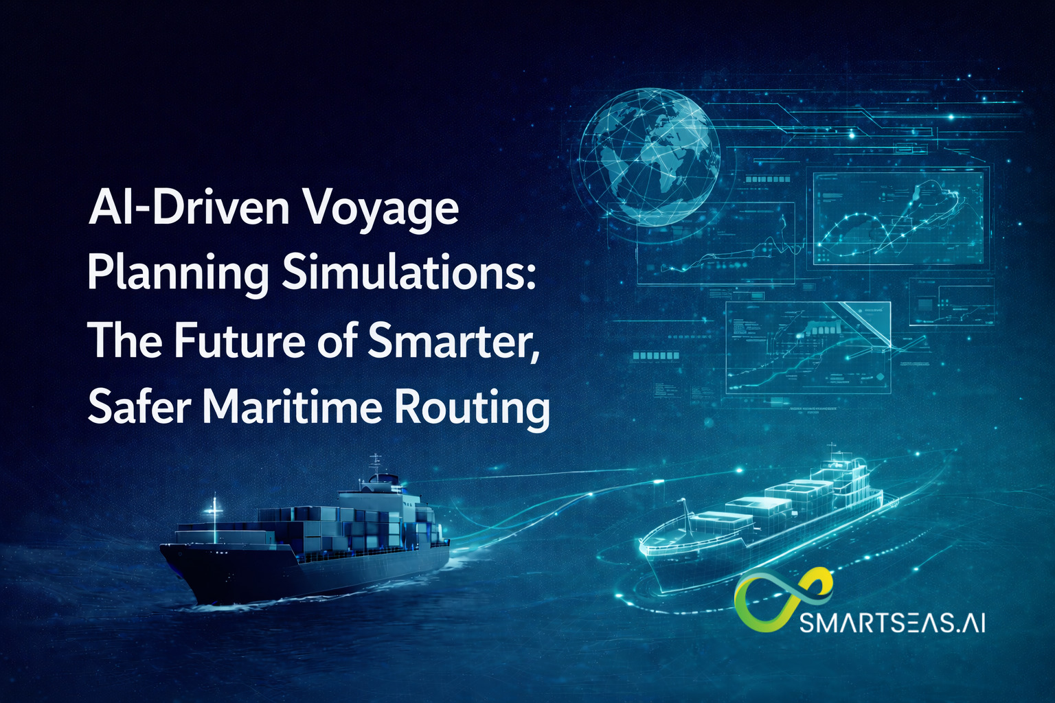
AI-Driven Voyage Planning Simulations: The Future of Smarter, Safer Maritime Routing

January 24, 2026
Every voyage plan looks simple on a chart: depart port A, arrive port B, avoid hazards, meet ETA. But the real-world decision is far more complex—because ships don’t travel through a static environment. They travel through a moving, uncertain system where weather shifts by the hour, currents change across latitude bands, traffic density evolves, port schedules move, and operational constraints (engine limits, fuel strategy, draft, charter-party requirements) add layers of tradeoffs.
Historically, voyage planning has relied on a combination of:
That approach still works—until conditions become tight:
Now the question isn’t “What route should we take?”
It’s: “Which route-and-speed strategy performs best under uncertainty—while staying safe, legal, and commercially viable?”
That is exactly what AI-driven voyage planning simulations are designed to solve.
AI-driven voyage planning simulations are not just “a better weather route.” They are a decision system that:
A useful way to think about it:
This shift—from single-answer routing to scenario testing—is why simulations are becoming the backbone of “smarter routing.”
Three forces are pushing voyage planning into a new era:
Ships and shore teams can now access:
Digital-twin route optimizers are explicitly built around combining IoT vessel data + modeling + real-time analytics to keep planning aligned with “what the vessel can really do,” not what a brochure says it can do.
Even small efficiency gains now translate into direct financial and commercial impact—especially in Europe where shipping is being integrated into climate policy frameworks.
In short: the route you choose is increasingly tied to cost, not just operations.
Modern tools can evaluate huge numbers of candidate routes and speed profiles quickly—making it practical to run simulation engines as part of daily planning. Reuters notes that captains/operators now have access to software that can evaluate millions of routes daily (in the context of digital navigation tools and efficiency).
When you simulate a voyage, you can test:
Then you can quantify performance:
This is what makes simulation-driven planning feel like a step change: it converts voyage planning from “best guess + experience” into “tested options + measured tradeoffs.”
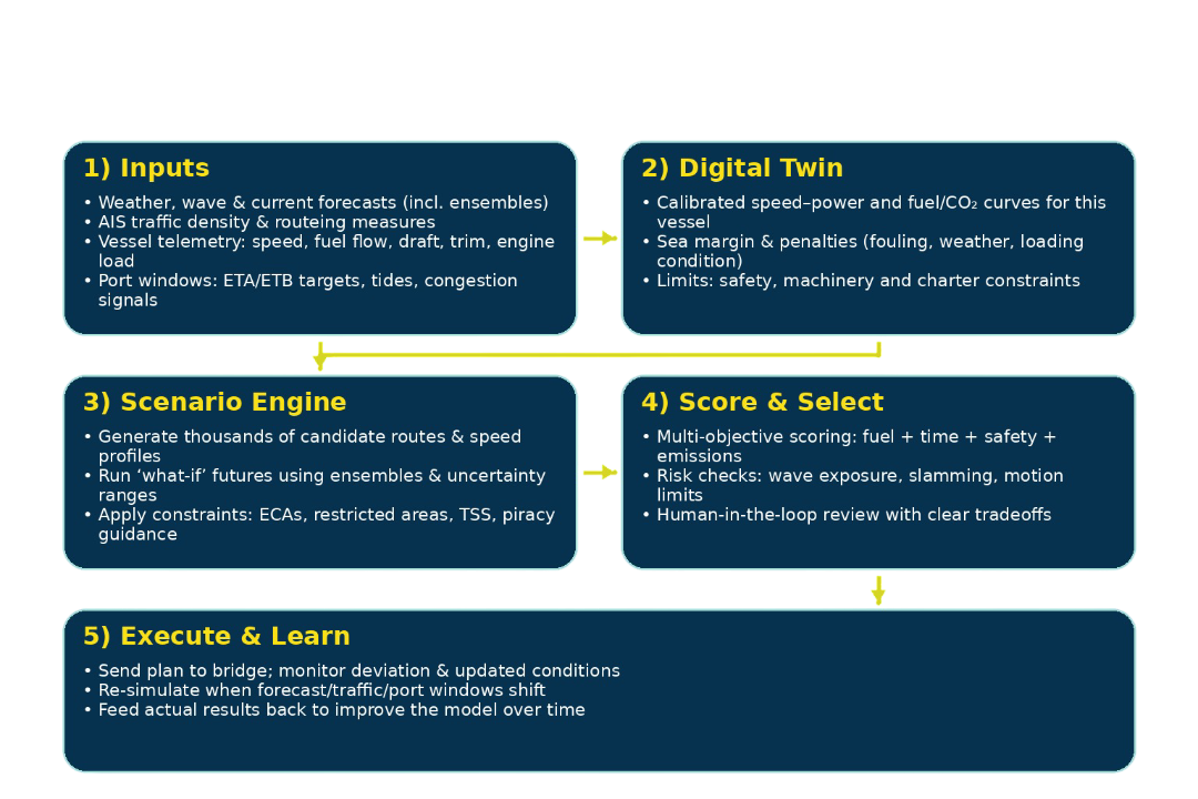
A modern simulation-based voyage planning loop: data → digital twin → scenario generation → scoring → execution → learning.
At a practical level, most systems follow a five-stage loop:
Common inputs include:
The biggest “hidden work” here is data quality. As Wärtsilä points out, to get the most out of AI solutions you need high-quality data—and lots of it.
A digital twin for voyage planning is essentially a calibrated performance model—how this specific hull and propulsion setup behaves under different conditions.
Industry explanations describe digital-twin route optimizers as fusing live onboard data streams and historical records, then simulating behavior under different scenarios to update route and speed recommendations as conditions change.
Hapag-Lloyd similarly highlights digital twins simulating routing scenarios using weather, currents, and port availability data.
This is where “simulation” becomes real:
The scoring function usually balances:
The output should not only be “Route A is best,” but:
Modern systems continuously re-check:
Then they re-run simulations and recommend adjustments.
Below are concrete, published examples showing what routing + simulation + vessel-performance modeling can achieve. Outcomes vary by vessel type, route, season, and operational discipline—but the pattern is consistent: simulation-driven planning produces measurable gains.
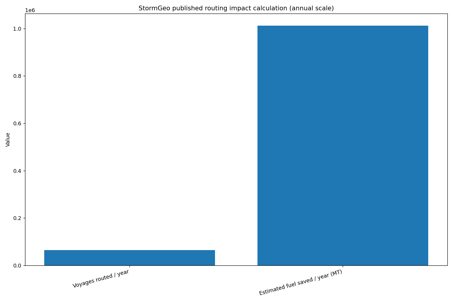
StormGeo published a “back-of-the-envelope” calculation based on the scale of their routing operations:
This is important for two reasons:
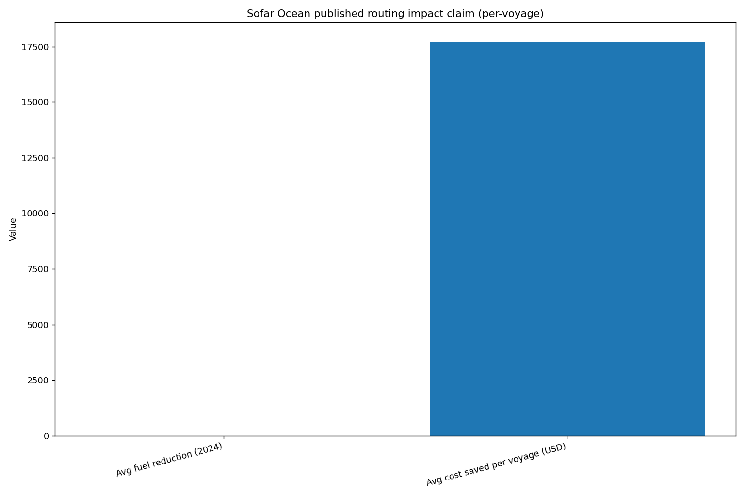
Reuters reported on Sofar Ocean’s approach: deploying a global network of buoys to measure wave and wind, improving forecast accuracy to guide more efficient routing. Reuters notes Sofar Ocean claims it cut fuel use by an average of 5.5% in 2024, saving $17,700 per voyage.
Why this matters:
DeepSea Technologies published results from work with Seanergy Maritime (Capesize bulkers):
This is a classic “digital twin” story: instead of generic routing rules, the optimizer learns how that vessel behaves in real sea states and recommends strategies that match its real performance envelope.
A peer-reviewed case study (Ocean Engineering, accessible via ScienceDirect) examined fuel savings from speed optimization across seasons and speeds for two case vessels:
This illustrates a key point: route geometry alone isn’t enough. A major part of “simulation-driven planning” is choosing the right speed policy across the voyage.
NAPA published results from a joint simulation project (NAPA + Norsepower + Sumitomo Heavy Industries) evaluating rotor sails plus voyage optimization:
This is the future direction: simulations won’t just pick routes—they’ll optimize how to use new propulsion and energy-saving devices intelligently under real weather patterns.
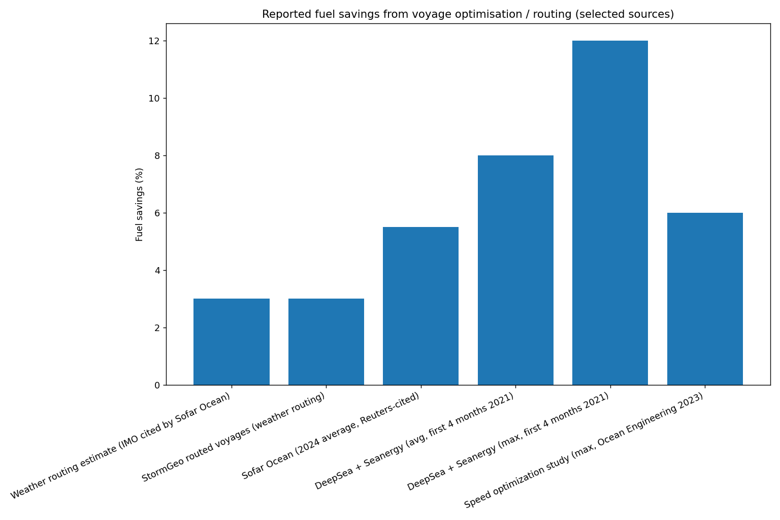
Published results and claims show consistent fuel savings potential from routing + optimization—ranging from ~3% to double digits depending on method, vessel, and conditions.
Important note: some figures above are company-published claims and/or simulation results; actual outcomes depend on vessel condition, crew adoption, charter constraints, and route seasonality.
Fuel savings get the headlines, but safety is often the bigger operational benefit—especially on routes prone to heavy weather.
A simulation-based routing engine can reduce risk by:
In other words: safety improves not because “AI is smarter,” but because simulation makes the consequences of decisions visible before the ship commits.
Hapag-Lloyd’s digital twin overview explicitly frames digital-twin routing as a way to avoid severe weather while reducing fuel consumption.
It’s increasingly hard to separate voyage planning from business planning because:
The EU ETS and FuelEU timelines matter because they make route efficiency a factor in competitive pricing and operational choices:
Routing simulations allow operators to test choices like:
Weather routing improves when it knows how the ship performs in real conditions.
That’s why “performance routing” case studies (like DeepSea + Seanergy) tend to show higher savings than generic routing.
Many voyages burn extra fuel not because the path is wrong, but because speed is managed conservatively, inconsistently, or without a quantified tradeoff model.
Peer-reviewed results show speed optimization alone can yield up to ~6% in tested cases.
A practical AI routing system doesn’t pretend the forecast is perfect. It evaluates “route robustness”:
This is why simulation is so powerful: it handles uncertainty directly.
The next frontier is route simulation tied to port windows.
NAVTOR’s DYNAPORT R&D description, for example, sets an explicit target of reducing ship fuel consumption by at least 10% through coordination tools and information sharing (project goal).
Even when these are goals rather than published realized savings, it signals where the industry is heading: ship + port decisions become one optimization problem.
As alternative fuels and dual-fuel strategies expand, route-and-speed decisions become even more economically sensitive.
A 2025 MDPI case study on joint route and speed optimization for methanol dual-fuel powered ships reported the approach could reduce operating costs by more than 15% versus conventional route and speed strategies (case study result).
Pick a primary outcome:
Starting with everything at once usually creates confusion.
Before optimization, record:
This baseline becomes your internal “truth set” to compare against.
You don’t need a perfect digital twin on day one. You can start with:
Then refine as telemetry improves.
This aligns with the broader industry narrative: digital twins are built by fusing design data, operational telemetry, and real-time analytics to better match “expected” vs “actual” performance.
A practical operating rhythm:
Routing recommendations must be:
Adoption improves when crews can see:
The real power of simulation-driven planning is feedback:
Over time, the digital twin becomes more accurate—making routing decisions increasingly reliable.
Fix: use ensembles and robustness scoring, not single deterministic routes.
Fix: define safety constraints first and treat them as “hard limits.”
Hull fouling and machinery condition can shift performance meaningfully. A living model is key.
Fix: build shared understanding and simple, transparent outputs.
Even the best optimizer fails if:
Savings come from decision quality + execution quality.
The NAPA wind-assist simulation results are a preview of a broader trend: routing engines will increasingly decide how to use energy-saving tech under specific weather patterns.
Digital twin concepts are spreading across ports and shipping lanes; Hapag-Lloyd points to digital twins analyzing routing scenarios that include port availability and real-time events.
Expect growth in:
Fleet-level engines will balance:
With EU ETS and FuelEU in force and IMO intensity measures already active, routing decisions will increasingly be audited internally and commercially—making “explainable optimization” a competitive advantage.
Elevate Your Fleet with the Industry’s Most Comprehensive AI Assistant
While voyage simulations provide the map, SmartSeas.AI provides the "brain" to execute it flawlessly. Specifically built for maritime operations, SmartSeas AI goes beyond simple routing by integrating vessel-specific digital twins with real-time troubleshooting and predictive maintenance. Whether you’re navigating tight EU ETS windows or managing complex engine loads mid-voyage, our platform unifies ship manuals, historical data, and live telemetry to help your crew make safer, faster, and more fuel-efficient decisions.
AI-driven voyage planning simulations are not a futuristic concept anymore. They are the practical response to modern shipping realities:
The strongest signal is the consistency of results across different sources:
The winners won’t be the companies that “have AI” on a slide.
They’ll be the operators who turn voyage planning into a repeatable simulation practice—where every route is tested, every tradeoff is visible, and every voyage makes the next one smarter.
No. Weather routing is usually one layer. AI-driven voyage planning simulations combine weather + vessel performance modeling + speed strategy + scenario testing, often updating recommendations continuously.
Published examples range from ~3% (commonly cited baseline for weather routing) to 8–12% in vessel-specific performance routing claims, with research showing up to ~6% for speed optimization in tested cases.
Actual results depend on vessel type, route, season, and execution discipline.
It improves safety by reducing exposure to severe conditions and by testing routes under multiple forecast scenarios rather than relying on a single plan.
Not necessarily. Many workflows can run as a hybrid: shore computes scenarios and sends updates; onboard teams execute and provide feedback. The key is operational design, not just connectivity.
Because efficiency and emissions intensity increasingly translate into direct operational cost and reporting exposure—EU ETS applies to maritime emissions from 2024, while FuelEU applies fully from 2025 and tightens over time.
Start with one lane, one vessel class, one objective (fuel or ETA reliability), build a baseline, and run “shadow mode” comparisons before changing operational routines.

Get Started Today
Transform the way you troubleshoot and manage maritime operations. Join the next wave of Maritime Digital Transformation with SmartSeas AI.